Looking at Kratovo options? Below are 2026 prices, vehicle categories, and the local-operator advantages for kratovo rock towers guide.
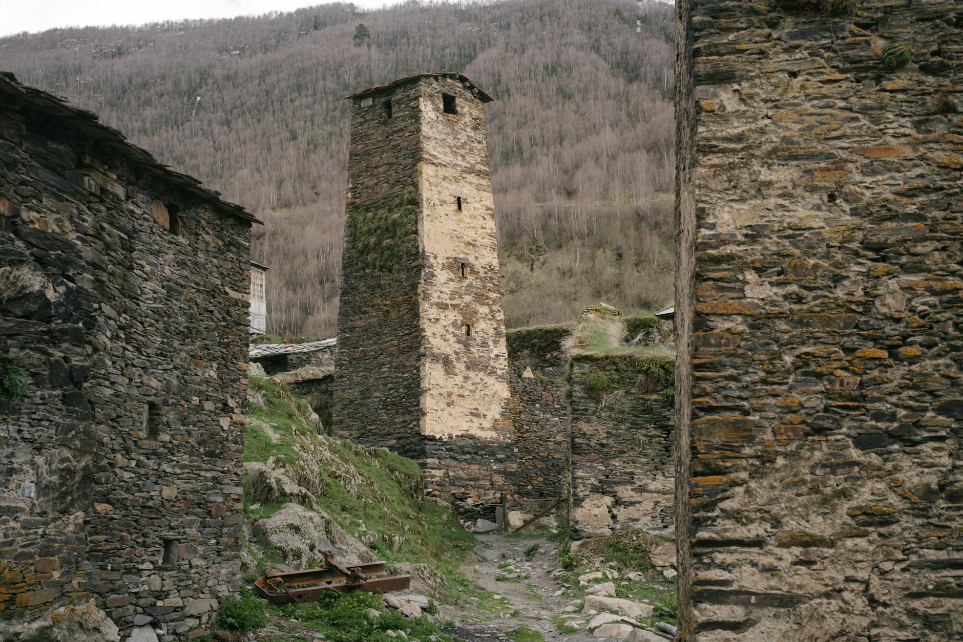
Kratovo is unlike anywhere else in North Macedonia. Built inside the crater of an extinct volcano, the town is surrounded by dramatic basalt rock formations and dissected by deep gorges. Medieval defence towers — six still standing — rise from the rocky hillsides, connected by stone bridges that span the ravines. The whole place looks like something from a fantasy novel. Most visitors to North Macedonia never hear of it. That is both the problem and the reason to go.
What Is Kratovo?
Kratovo (Кратово) is a town of about 7,000 people in northeastern North Macedonia, 90 km from Skopje. It sits in a natural bowl created by volcanic activity in the distant geological past. The volcanic basalt left behind a landscape of dramatic rock columns, dark stone bridges, and a natural fortification that medieval settlers exploited to the maximum.
The Romans knew the site as Kratiskara and mined copper here. Under Byzantine and Serbian medieval rule, the town developed its distinctive tower architecture — wealthy merchant and feudal families competed to build the tallest defensive tower. At peak construction, there were reportedly 16 towers. Six remain in good condition.
What makes Kratovo exceptional:
- The natural volcanic crater setting — visible from the road approach
- Six medieval towers, some open to climb
- Stone bridges arching over the gorge ravines within the town
- Intact Ottoman-era bazaar and clocktower
- Almost no international tourism — you'll likely have the place to yourself
Getting There from Skopje
Distance: 85 km northeast Drive time: 1 hour 15 minutes Route: Take the E871 east from Skopje toward Kumanovo, then south at the Kratovo junction on the regional road. The final approach descends into the volcanic bowl — you'll see the towers emerging from the rock before you reach the town.
The road is in good condition throughout. No motorway, but the regional road is wide, well-maintained, and entirely navigable in a standard car.
Parking: Free parking is available at the town entrance near the clocktower. The old town centre is pedestrianised; park and walk.
The Six Medieval Towers
The towers were originally used as watchtowers, grain stores, and places of refuge during raids. Each was built by a different noble family or wealthy merchant; height was a direct statement of status and wealth.
Saat Kula (Clocktower): The most prominent landmark, visible on approach. Ottoman-era clock added later. Open for climbing — 360° view of the entire crater basin. Worth it.
Krstevkula: One of the better-preserved towers, adjacent to a small Orthodox church. The contrast between the dark basalt tower and the whitewashed church is highly photogenic.
Zlatareva Kula (Goldsmith's Tower): Named after the goldsmith guild that occupied the building. Ground-floor interior is open.
Simićeva Kula, Ćurčijskakula, Hadži Kostova Kula: Vary in state of preservation; all visible from the walking circuit around the old town.
Walking time to visit all towers: 2–2.5 hours at a relaxed pace, including climbs to two of the taller ones.
The Bridges
Within the old town, several stone bridges span the ravines and connect the different neighbourhoods. These are not decorative additions — the gorges are real, dropping 10–20 metres to the streams below, and the bridges were functional infrastructure.
The Radin Most is the most photographed — an arched stone bridge framing a view down the gorge toward one of the towers. The scene is particularly striking in morning light (east-facing gorge, best before 10:00) and in autumn when the vegetation in the ravine turns colour.
The Volcanic Landscape Around Kratovo
The basalt rock formations visible throughout the Kratovo area formed from volcanic eruptions approximately 23 million years ago. The subsequent erosion created the column structures and gorge topography.
Kuklica rock formations (10 km south of Kratovo): A field of volcanic stone columns reaching 10 metres in height, scattered across an open hillside. Local legend calls them "stone puppets" (kuklici) — petrified wedding guests. The reality is erosion-sculpted volcanic basalt, but the visual effect is otherworldly. This is the closest thing to Cappadocia in the Balkans.
Access to Kuklica: Drive south from Kratovo toward the village of Kuklica (well-signed). The rock field is a 5-minute walk from the road. Free to visit; no facilities. Best in morning light. Allow 1 hour for the detour.
The Old Bazaar and Ottoman Quarter
Kratovo's Ottoman-era bazaar has survived better than many in the region — a small but intact set of craftsmen's shops and covered market lanes. The metalworking tradition here goes back to the Roman copper mines; you'll still find local artisans working copper and brass.
Clocktower square functions as the town centre. Café tables on the terrace above the gorge make it one of the best coffee stops in northeastern Macedonia — strong Macedonian coffee, quiet surroundings, tower and gorge view.
Combining Kratovo with Other Day Trips
Kratovo + Kokino Observatory (30 km northeast): A half-day extension to Kratovo. Kokino is a 3,800-year-old Bronze Age astronomical site on a volcanic ridge — listed by NASA as one of the most important ancient observatories in the world. The two volcanic sites complement each other perfectly. See our Kokino guide.
Kratovo + Štip (50 km south): Štip is the textile industry capital of North Macedonia with a fortress and attractive old town. An eastern Macedonia circuit could combine Kratovo (morning) with Štip (afternoon lunch stop) and return to Skopje via the main road.
Full northeastern Macedonia day: Kratovo → Kuklica rock formations → Kokino Observatory → return to Skopje. Total driving: approximately 250 km, 5 hours including stops. Start early.
Kratovo is one of the best photography destinations in North Macedonia. The combination of basalt stone, medieval towers, and gorge bridges creates compositions that are unlike anything else in the country.
Best shots:
- Radin Most bridge with gorge and tower behind (morning light)
- View from Saat Kula clocktower over the crater bowl (any time of day)
- Kuklica rock columns (morning or late afternoon — midday light is flat)
- The Ottoman bazaar lanes with metalwork stalls
Bring a wide-angle lens for the gorge bridges and a longer lens for detail shots of the tower stonework.
Practical Information
| Detail | Information |
|---|---|
| Distance from Skopje | 85 km (1h 15min) |
| Parking | Free at town entrance |
| Tower entry fees | Clocktower: ~€1; others free or small donation |
| Kuklica rock formations | Free; 10 km south of town |
| Best time | Morning (gorge light) or autumn (colour) |
| Facilities | Cafés and restaurants on clocktower square |
| Fuel | Fill in Skopje; petrol station in Kratovo centre |
Getting there: Relax Rent a Car Skopje Airport has operated since 2001 from Alexander the Great Airport (SKP), serving travellers across North Macedonia and the Western Balkans.
Book a rental car at Skopje Airport — reach Kratovo from SKP in under 1.5 hours.
Related: Kokino Observatory guide | Photography spots in North Macedonia | Best day trips from Skopje | Stobi archaeological site | North Macedonia complete road trip guide
Frequently Asked Questions
What are the Kratovo rock towers? The rock towers of Kratovo (locally called "kuli" — towers) are medieval stone fortifications built between the 11th and 14th centuries, when Kratovo was a prosperous Ottoman mining town producing lead and silver. Six towers survive, connected by bridges and walls across the ravine. The Clock Tower (Sahat Kula) is the most prominent and best-preserved. The towers were used for defense and administrative control of the mining district.
How far is Kratovo from Skopje? Kratovo is 85 km from Skopje (approximately 1 hour 15 minutes via the E75 motorway east toward Kumanovo, then south). It makes a comfortable half-day or full-day trip. The route passes through flat plains before the terrain becomes volcanic and the gorge town appears — the visual contrast is striking.
What are the Kuklica rock formations near Kratovo? The Kuklica rock formations (10 km south of Kratovo) are natural volcanic tuff pillars — up to 10 metres tall — eroded over millennia into human-like shapes. Local legend calls them a "petrified wedding" (petrified guests, bride, and groom). They are unique in the Balkans and considered one of North Macedonia's geological curiosities. Free access, no facilities, best visited in morning light.
Can I combine Kratovo with Kokino Observatory in a day trip? Yes — Kokino Observatory is 27 km northeast of Kratovo (30 minutes). The combination makes a logical day trip: drive east from Skopje to Kokino for sunrise or morning, then continue south to Kratovo for lunch and the clock tower, return to Skopje in the afternoon. Total driving from Skopje: approximately 220 km.
Is Kratovo worth visiting? Yes, particularly for travellers who want to see a genuinely different side of North Macedonia. The gorge setting, the medieval stone bridges, the Ottoman-era tower architecture, and the lack of tourist crowds make it one of the most atmospheric small towns in the country. The Kuklica formations add a unique natural element that has no equivalent elsewhere in the region.